Shapefile Command Line Tool
This is a command line tool to help to inspect a specified shapefile. It provides function to inspect a specified shapefile's header, fields, records etc.
Install
# global installnpm i -g ginkgoch-shapefile-cli # local installnpm i --save ginkgoch-shapefile-cliHelp
shapefile-cli --helpUsage: index command [options] <file>
Options:
-V, --version output the version number-h, --help output usage informationCommands:
show-header [options] <file> Output shapefile header informationshow-fields [options] <file> Output shapefile fields informationshow-records [options] <file> Output shapefile records informationconvert-geojson [options] <file> Convert shapefile to GeoJsonbuild-index [options] <fileOrDir> Build index for shapefilereproject [options] <file> Re-project shapefile to a specific SRSserve [options] <fileOrDir> Launch a server for exploring shapefile(s) on browserShow Header
Show header help
node index.js show-header --helpUsage: show-header [options] <file>
Options:
-p, --pretty output header with pretty table format-h, --help output usage informationExample - print a shapefile's header with pretty table format
shapefile-cli show-header ~/Downloads/data/shp/USStates.shp -p╔════════════╤═════════════════════╗║ fileCode │ 9994 ║╟────────────┼─────────────────────╢║ fileLength │ 222344 ║╟────────────┼─────────────────────╢║ version │ 1000 ║╟────────────┼─────────────────────╢║ fileType │ Polygon ║╟────────────┼─────────────────────╢║ minx │ -178.21502685546875 ║╟────────────┼─────────────────────╢║ miny │ 18.924781799316406 ║╟────────────┼─────────────────────╢║ maxx │ -66.9698486328125 ║╟────────────┼─────────────────────╢║ maxy │ 71.40664672851562 ║╚════════════╧═════════════════════╝Show Fields
Show fields help
shapefile-cli show-fields --helpUsage: show-fields [options] <file>
Options:
-p, --pretty  output fields with a pretty table format
-h, --help    output usage information
Example - print a shapefile's fields info in pretty table format.
shapefile-cli show-fields ~/Downloads/data/shp/USStates.shp -p╔════════════╤══════╤════════╤═════════╗║ name │ type │ length │ decimal ║╟────────────┼──────┼────────┼─────────╢║ AREA │ N │ 12 │ 3 ║╟────────────┼──────┼────────┼─────────╢║ PERIMETER │ N │ 12 │ 3 ║╟────────────┼──────┼────────┼─────────╢║ STATE_ │ N │ 11 │ 0 ║╟────────────┼──────┼────────┼─────────╢║ STATE_ID │ N │ 11 │ 0 ║╟────────────┼──────┼────────┼─────────╢║ STATE_NAME │ C │ 25 │ NaN ║╟────────────┼──────┼────────┼─────────╢║ STATE_FIPS │ C │ 2 │ NaN ║╟────────────┼──────┼────────┼─────────╢║ SUB_REGION │ C │ 7 │ NaN ║╟────────────┼──────┼────────┼─────────╢║ STATE_ABBR │ C │ 2 │ NaN ║╟────────────┼──────┼────────┼─────────╢║ POP1990 │ N │ 9 │ 0 ║╟────────────┼──────┼────────┼─────────╢║ RECID │ N │ 9 │ 0 ║╚════════════╧══════╧════════╧═════════╝Show Records
Show records help
shapefile-cli show-records --helpUsage: show-records [options] <file>
Options:
-l, --limit <n> returning records limit. accept any number. 0 means all records. default to 10-c, --columns <items> returning columns include in the results. Multiple columns are supported by separater ",". Default to all columns-g, --geom includes geometry in the returned content-p, --pretty output records with a pretty table format-h, --help output usage informationExample - print a shpefiles's top 10 records info with field name STATE_NAME, RECID and geometry in pretty table format.
shapefile-cli show-records ~/Downloads/data/shp/USStates.shp -g -l 10 -c STATE_NAME,RECID ╔══════════════╤═══════╤════════════════════════════════╗║ STATE_NAME │ RECID │ geom ║╟──────────────┼───────┼────────────────────────────────╢║ Washington │ 1 │ [[{"x":-122.40074920654297,... ║╟──────────────┼───────┼────────────────────────────────╢║ Montana │ 2 │ [[{"x":-111.4746322631836,"... ║╟──────────────┼───────┼────────────────────────────────╢║ Maine │ 3 │ [[{"x":-69.77778625488281,"... ║╟──────────────┼───────┼────────────────────────────────╢║ North Dakota │ 4 │ [[{"x":-98.73005676269531,"... ║╟──────────────┼───────┼────────────────────────────────╢║ South Dakota │ 5 │ [[{"x":-102.78793334960938,... ║╟──────────────┼───────┼────────────────────────────────╢║ Wyoming │ 6 │ [[{"x":-104.05310821533203,... ║╟──────────────┼───────┼────────────────────────────────╢║ Wisconsin │ 7 │ [[{"x":-87.74845123291016,"... ║╟──────────────┼───────┼────────────────────────────────╢║ Idaho │ 8 │ [[{"x":-117.02530670166016,... ║╟──────────────┼───────┼────────────────────────────────╢║ Vermont │ 9 │ [[{"x":-73.25850677490234,"... ║╟──────────────┼───────┼────────────────────────────────╢║ Minnesota │ 10 │ [[{"x":-91.73021697998047,"... ║╚══════════════╧═══════╧════════════════════════════════╝ Reading complete. 10/51 record(s) Tips: - set option -l, --limit to 0 to read all records - use option -g, --geom to 0 to read all records with geometry - use option -p, --pretty to return data with pretty table format - use option -c, --column to return necessary fields. e.g. -c field1,field2 returns two fieldsConvert to GeoJson
Convert shapefile to GeoJSON format help
shapefile-cli convert-geojson --helpUsage: convert-geojson [options] <file>
Options:
-c, --columns <items> returning columns include in the results. Multiple columns are supported by separater ",". Default to all columns-o, --output <value> output file path. If only directory is specified, the same file name will be used. Default to the same folder of the sourceShapefile-h, --help output usage informationExample - converts a shapefile to GeoJson format.
shapefile-cli convert-geojson ./tests/data/USStates.shp Conversion complete. New file is saved at ./tests/data/USStates.json.Build index
Build spatial index help
shapefile-cli build-index --helpUsage: build-index [options] <fileOrDir>
Options:
-w, --overwrite Overwrite Re-projection
Re-project from current coordinate system to another help
shapefile-cli reproject --helpUsage: reproject [options] <file>
Options:
--outputSrs <outputSrs> [Required] The target SRS. It is required--sourceSrs <sourceSrs> the source SRS. If .prj file doesn't exist, this option will be applied as source SRS-o, --output <output> the output shapefile path. Default is the source file name with "_[targetSRS]" suffix-w, --overwrite overwrite if index files exist. Default is "false"-h, --help output usage informationLaunch a server
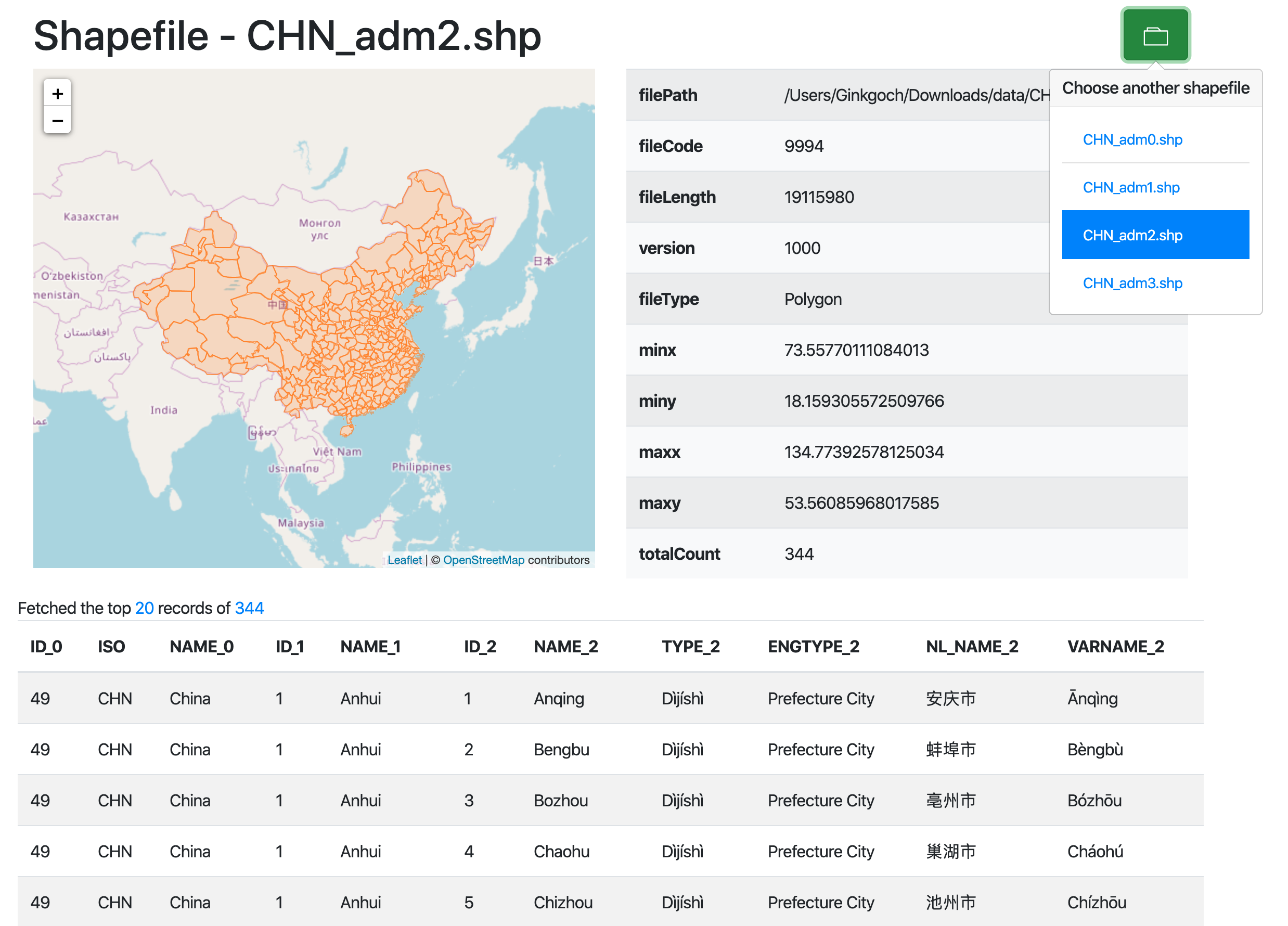
Launch a server for exploring shapefile on browser.
shapefile-cli reproject --helpUsage: serve [options] <fileOrDir>
Options:
-p, --port <port> the server port exposed to browse, default port is 3000-h, --help output usage informationTake a look at a screenshot of serving a specific directory:
Issues
Contact ginkgoch@outlook.com or submit an issue.