Socioscapes.js - a Javascript GIS library
Socioscapes is a javascript alternative to desktop geographic information systems and proprietary data visualization platforms. The modular API fuses various free-to-use and open-source GIS libraries into an organized, modular, and sandboxed environment.
Details
Current version: 0.7.2-2
(expect breaking changes prior to version 1.0)
Source code: http://github.com/moismailzai/socioscapes
Reference implementation: http://app.socioscapes.com
License: MIT license (free as in beer & speech)
Copyright: © 2016 Misaqe Ismailzai
Installation
Standalone: regular
<script src="https://cdn.rawgit.com/moismailzai/socioscapes/master/socioscapes.js">NodeJS: npm
npm install socioscapes
Bower: bower
bower install socioscapes
Dependancies
geostats: Simon Georget's geostats library for classifications and basic statistics.
chroma: Gregor Aisch's chroma library for all-things-colour.
What Does It Do?
For developers, socioscapes provides an extendable asynchronous API that standardizes interaction with various open-source tools and standards. For the end user, socioscapes allows simple and easy file management: you should be able to save, edit, and share your work in an intuitive, non-proprietary format. Rather than reinvent the wheel, socioscape '.scape' files are simply containers that transparently organize the data you choose to work with. A .scape file is just a JSON object with the following structure:
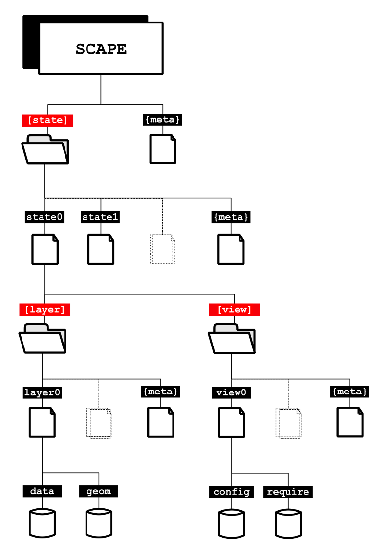
The above is a visual representation of the socioscapes [scape] class, which is itself composed of [state], [layer], and [view] classes. All class instances include a {meta} object that holds arbitrary data unique to the instance, such as a name, an author, and a source. Since the {scape} object is itself just an instance of the [scape] class, it also includes a {meta} member.
The [state] array stores instances of the [state] class, which are meant to organize all of the data and configuration necessary to reproduce a corresponding DOM state. This structure fascilitates comparative and time series visualization. For instance, suppose a user wishes to demonstrate a change in the way income is distributed across their city. They could create several {state} instances, one for each point in the time series. This allows for maximum data mobility because each {state} is entirely independent of the others and can be edited, saved, and shared independently.
Now suppose that besides a map, the user also wishes to include some charts, graphs, and tables. Socioscapes approaches this problem by organizing each {state} into [layer] and [view] stores. {layer} objects are static collections of raw numerical and geometric data; {view} objects are indexes that store settings and point to data necessary to recreate a particular element (such a chart). Views are directly incorporated into the DOM whereas layers are just datastores. The above schema is not set in stone and users can use socioscapes.fn.extender() to edit, remove, and add additional classes. To get a feel for the API, jump into the code or read through the following examples:
Usage:
Note: While the servers and datasets in these examples are functioning, due to XSS security it is not possible to test these from an outside domain. However, app.socioscapes.com hosts a publically exposed copy of the socioscapes API which can be accessed via the developer's console and which has been configured to access the example servers. Don't forget to change the Big Query client id to your Google client id, found in the Google Developer Console).
using the api
// create a new scape object to store our work in. let's call it 'tdot'. if you don't specify a new scape, the api uses the default one ('scape0')
// all scapes are created with a default state ('state0'), and all states are created with a default layer ('layer0') and view ('view0'). these defaults are loaded if .state(), .layer(), or .view() are called without an argument.
// lets check the newly created 'tdot' scape object to get a sense of the socioscapes datastructure
tdot // creating a new socioscapes object of any class is simple
// okay, let's download some Toronto census data to work with. socioscapes has native support for WFS geometry in geoJSON format and can parse Google Bigquery results. let's set all that up (these variables, "bq" and "wfs", are preconfigured and publicly exposed on the reference implementation website).
var wfs = "http://app.socioscapes.com:8080/geoserver/socioscapes/ows?service=WFS&version=2.0.0&request=GetFeature&typeName=socioscapes:2011-canada-census-da&outputFormat=json&cql_filter=csduid=3520005";var bq = auth: SERVICETOKEN clientId: <<< REPLACE WITH YOUR GOOGLE APIS CLIENT ID >>> id: '2011_census_of_canada' featureIdProperty: 'dauid' projectId: '424138972496' queryString: "SELECT dauid, SUM(IF(REGEXP_MATCH(question, r'(^1$)'),total,0)) as characteristic, SUM(IF(REGEXP_MATCH(question, r'(^7$)'),total,0)) as normalization, SUM(IF(REGEXP_MATCH(question, r'(^1$)'),total,0))/SUM(IF(REGEXP_MATCH(question, r'(^7$)'),total,0)) as total FROM [canada_census_2011.ontario] WHERE csduid CONTAINS '3520005' AND (REGEXP_MATCH(question, r'(^1$)') OR REGEXP_MATCH(question, r'(^7$)') )GROUP BY dauid;"; data'bq' bq // too verbose? the api is setup that way so you can add callbacks at every link. but you can create navigation shortcuts if you prefer
l = v = ldata'bq' bq; v// putting it all together: using the configuration objects we created above, the code snippet below will create a new scape object called tdot, create a state called census2011, fetch and parse wfs geometry, fetch related google bigquery data, create a new google map, organize the data based on default values and render it to the view if there is a "map-canvas" div present.
data'bq'bq; Socioscapes Events:
To aid with unidirectional data flow, the API fires the following events:
ScapeMenu is created: fires 'socioscapes.newScapeMenu' with event.detail = scapeMenu;
ScapeObject is created: fires 'socioscapes.newScapeObject' with event.detail = scapeObject;
viewGmapSymbology completed: fires 'socioscapes.updateSymbology' with event.detail = socioscapesView;
Asynchronous:
The socioscapes Dispatcher class helps to facilitate asynchronous method chaining and queues. Socioscapes associates every 'scape' object with a unique dispatcher instance and id. The dispatcher allows for API calls to be queued and synchronously resolved on a per-scape basis by attaching a unique dispatcher instance to every scape. The api itself remains asynchronous. Calls to the dispatcher are expeted to provide an arguments array, myArguments, and a function, myFunction. The first argument in myArguments should always be the object that myFunction modifes and/or returns. myFunction is evaluated for the number of expected arguments (myFunction.length) and the dispatcher appends null values for expected arguments that are missing. This is done so that a callback function can be appended to the array and all functions that are executed through the dispatcher can safely assume that the element at index myArguments.length is the dispatcher callback. Finally, a queue item consisting of the myFunction and myArguments members is pushed into the dispatcher's queue array. The dispatcher works through each item in its queue by executing myFunction(myArguments) and waiting for the callback function to fire an event that signals that the function has returned a value and the dispatcher can safely move on to the next item its queue.
Extendable:
The socioscapes structure is inspired by the jQuery team's module management system. To extend socioscapes, you simply need to call 'socioscapes.extender' and provide an array of entries that are composed of an object with '.path' (a string), and '.extension' (a value) members. The '.path' Tells the API where to store your extension. The path for most modules will be the root path, which is socioscapes.fn. The name of your module should be prefixed such that existing elements can access it. For instance, if you have created a new module that retrieves data from a MySql server, you'd want to use the 'fetch' prefix (eg. 'fetchMysql').
This software was originally written as partial fulfilment of the Masters Research Paper, a degree requirement for the Masters of Arts in Sociology at the University of Toronto.