Americana Shield Renderer
The Americana shield renderer is a library intended to draw highway shields on a maplibre-gl-js vector-tiled map.
Shield rendering workflow
Rendering shields requires the following compoments:
-
Encode shield information in vector tiles. First, your tiles must contain the information which tells the shield renderer what shields to draw. In OpenMapTiles, shield information is encoded in the
transportation_namevector tile layer with a series of attributes namedroute_1,route_2, etc. Each attribute contains a text string which contains all of the information needed to determine which graphic to display, including numeric route number if the shield is numbered. However, this library allows you to specify how the shield information has been encoded, and it's possible to stitch together data from multiple fields when encoding shield data. -
Expose shield information in a style layer. Next, route information must be exposed in a maplibre expression using image in a structured string containing the route information. For example, you might encode Interstate 95 as an image named
shield|US:I=95. Normally, the image expression is used to point to pre-designated sprites in a sprite sheet, but in this case, we're pointing to a sprite which doesn't exist calledshield|US:I=95. This will trigger astyleimagemissingevent which allows the shield renderer to create the required graphic on the fly. As an example of how to encode shield information, see OSM Americana'shighway_shieldstyle layer. -
Define a parser that describes how route information is encoded. There are three parts to a route definition:
- The
networkstring, which defines a network with a common shield shape, graphic, and color - The
refstring, which defines a text sequence that should be drawn on top of the shield graphic - The
namestring, which defines a name, separate from the ref, that is used to determine which graphic to draw
let routeParser = {
  //format is `shield|${network}=${ref}|${name}`
  parse: (id: string) => {
    let id_parts = id.split("|");
    let network_ref = id_parts[1].split("=");

    return {
      network: network_ref[0],
      ref: network_ref[1],
      name: id_parts[2],
    };
  },
  format: (network: string, ref: string, name: string) =>
    `shield|${network}=${ref}|${name}`,
};
- The
-
(Optional) Create predicates that define which shields will be handled. For example, if all sprite IDs in your style that need a shield begin with the string
shield|, this would look like:let shieldPredicate = (imageID: string) => imageID.startsWith("shield");
This step can be skipped if all unhandled image IDs are shields.
Additionally, you can specify which networks will be handled. The example below ignores all
nwn,lwn,ncn, etc. network values:let networkPredicate = (network: string) => !/^[lrni][chimpw]n$/.test(network);
-
Create shield definitions and artwork. The shield definition is expressed as a JSON file along with a set of sprites containing any raster artwork used for the shields. It can be generated as an object or hosted as a JSON file accessible by URL. See the next section for how to create this definition.
-
Hook up the shield generator to a maplibre-gl-js map. Pass either the URL of the JSON shield definition or create an object in javascript code. There are two separate classes for each approach.
new URLShieldRenderer("shields.json", routeParser)
  .filterImageID(shieldPredicate)
  .filterNetwork(networkPredicate)
  .renderOnMaplibreGL(map);
new ShieldRenderer(shields, routeParser)
  .filterImageID(shieldPredicate)
  .filterNetwork(networkPredicate)
  .renderOnMaplibreGL(map);
Shield Definition
The purpose of the shield definition is to define which graphics and text to draw for each network/ref/name combination that you wish to display. This can be created in javascript as an object, or as an HTTP-accessible JSON file.
This description uses the following conventions:
- A network is a set of routes with a common graphical presentation. Each route may have variations in appearance, such as a different route number, or a special case definition as described below. The network value corresponds in concept to the OpenStreetMap network tag.
- A ref contains the text to be drawn on shield artwork. The ref value corresponds in concept to the OpenStreetMap ref tag.
The structure is as follows:
{
    "options": {
      "bannerHeight": 9,
      "bannerPadding": 1,
      "bannerTextColor": "black",
      "bannerTextHaloColor": "white",
      "shieldFont": "'Noto Sans Condensed', sans-serif-condensed, 'Arial Narrow', sans-serif",
      "shieldSize": 20
    },
    "default": { ...definition },
    "network_1": { ...definition },
    "network_2": { ...definition },
    "network_3": { ...definition }
}
The options block contains global parameters that apply across all shield drawing:
-
bannerHeight: height of each text banner -
bannerPadding: padding between each banner -
bannerTextColor: color to draw text banners above the shield -
bannerTextHaloColor: color to draw an outline around the text banner -
shieldFont: ordered list of fonts to use for shield text and banners. This project uses Noto Sans Condensed by default, hosted as a downloadable web font on another repository. -
shieldSize: "standard" size to use for shields in 1x pixels. However, some shields may diverge, for example, drawn diamond shields are drawn slightly larger for visual similarity with squares.
You should create one definition entry for each network. The entry key must match the encoded network value exactly. The "default" network defines what should be drawn if there's no definition for a particular network. A network definiton can contain any combination of the following parameters:
{
  "textColor": "black",
  "textHaloColor": "white",
  "padding": {
    "left": 3,
    "right": 3,
    "top": 3,
    "bottom": 3
  },
  "spriteBlank": "name_of_image_1",
  "noref": {
    "spriteBlank": "name_of_image_2"
  }
  "shapeBlank": {
    "drawFunc": "pentagon",
    "params": {
      "pointUp": false,
      "yOffset": 5,
      "sideAngle": 0,
      "fillColor": "white",
      "strokeColor": "black",
      "radius1": 2,
      "radius2": 2
    }
  },
  "banners": ["ALT"],
  "bannerTextColor": "#000",
  "bannerTextHaloColor": "#FFF",
  "textLayout": {
    "constraintFunc": "roundedRect",
    "options": {
      "radius": 2
    }
  },
  "colorLighten": "#006747",
  "overrideByRef": {
    "REF": {
      "spriteBlank": "special_case_image",
      "textColor": "#003f87",
      "colorLighten": "#003f87"
    }
  },
  "refsByName": {
    "Audubon Parkway": "AU"
  },
  "overrideByName": {
    "Merritt Parkway": {
      "spriteBlank": "shield_us_ct_parkway_merritt"
    }
  }
}
Shield property descriptions
-
textColor: determines what color to draw therefon the shield. -
textHaloColor: color to draw a knockout halo around thereftext. -
padding: padding around theref, which allows you to squeeze the text into a smaller space within the shield. -
spriteBlank: specify the name of an image in the sprite sheet to use as the shield background. This can either be a single string or an array of strings if there are multiple options for different width. If it's an array of strings, they must be ordered from narrowest to widest, and the engine will choose the narrowest shield graphic that fits the text at a reasonable size. -
noref: specify alternate attributes to apply in the event that norefis supplied. This allows you to use one graphic for numbered routes and a separate unitary graphic for non-numbered routes within the same network. SupportsspriteBlank,colorLighten, andcolorDarken. -
shapeBlank: specify that a shield should be drawn as a common shape (rectangle, ellipse, pentagon, etc), with colors and dimensions as specified. See the drawn shield shapes section for available drawing options. -
banners: specify that one or more short text strings (up to 4 characters) should be drawn above the shield. This is specified as an array, and text will be drawn in order from top to bottom. Below is an example of bannered shields with up to three banners:
-
bannerTextColor: specify the color of the banner text. -
bannerTextHaloColor: specify the color of the banner knockout halo. -
textLayout: specify how text should be inscribed within the padded bounds of the shield. The text will be drawn at the maximum size allowed by this constraint. See the text layout functions section for text layout options. -
colorLighten: specify that the shield artwork should be lightened (multiplied) by the specified color. This means that black areas will be recolor with this color and white areas will remain the same. Alpha values will remain unmodified. -
colorDarken: specify that the shield artwork should be darkened by the specified color. This means that white areas will be recolor with this color and black areas will remain the same. Alpha values will remain unmodified. -
overrideByRef: specify that a specificrefwithin anetworkshould have different shield properties than other routes in the network, with one entry per special-caseref. Supported options arespriteBlank,textColor, andcolorLighten. -
refsByName: specify that anamewith the specified key should be treated as arefwith the specified value. -
overrideByName: specify that particularnameshould use a specificspriteBlankwhich differs from the rest of the network.
Handling special case networks
The shield specification allows for the handling of special cases. For example, in OSM Americana, we wanted to create special shields for the Kentucky Parkway System. This network used a particularly ugly set of shields that looked something like this:

The Americana team wanted to draw a series of shields that used two-letter codes to represent each of the Parkways, so that it would look like this:
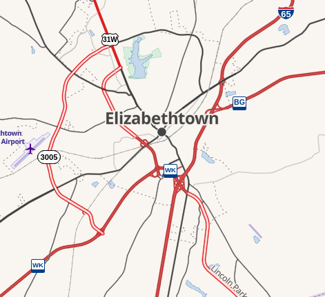
However, these two-letter codes weren't actually used as route numbers on shields, so it wasn't appropriate to add them to the ref=* tag in OpenStreetMap. Instead, the team used the refsByName property, and then defined what two-letter code is assigned to each named route network as follows:
  "US:KY:Parkway": {
    "spriteBlank":"shield_us_ky_parkway",
    "textColor":"#003f87",
    "padding": {
      "left":2,
      "right":2,
      "top":2,
      "bottom":6
    },
    "refsByName": {
      "Audubon Parkway":"AU",
      "Bluegrass Parkway":"BG",
      "Bluegrass Pkwy":"BG",
      "Cumberland Parkway":"LN",
      "Cumberland Pkwy":"LN",
      "Hal Rogers Parkway":"HR",
      "Hal Rogers Pkwy":"HR",
      "Mountain Parkway":"MP",
      "Mountain Pkwy":"MP",
      "Purchase Parkway":"JC",
      "Purchase Pkwy":"JC",
      "Western Kentucky Parkway":"WK",
      "Western Kentucky Pkwy":"WK"
    }
  },
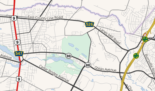
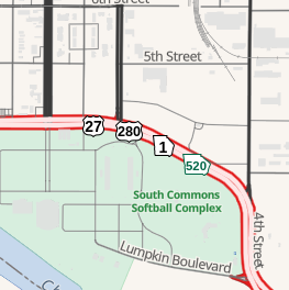
Another special case is when select routes within a network need to be styled differently. For example, Georgia State Route 520 is signed with a green-colored shield, while the default color for Georgia state highways is black. The shield assembly below shows an intersection and concurrency with both styles of Georgia state route:
This effect can be achieved by overriding the text and sprite color in the route definition as follows. For multiple special case refs, add multiple entries.
"US:GA": {
  "spriteBlank": ["shield_us_ga_narrow", "shield_us_ga_wide"],
  "textColor": "black",
  "overrideByRef": {
    "520": {
      "textColor": "#006747",
      "colorLighten": "#006747"
    }
  }
}
In this example, the two shield_us_ga_... sprite blanks represent the narrow and wide versions of the Georgia state route shield, and are colored black with white fill. This results in the following:
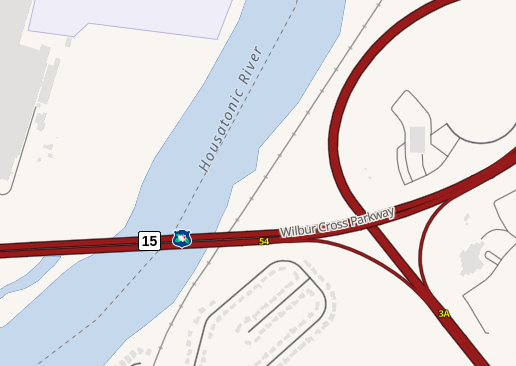
Finally, the last special case is when one named route in a network requires a different shield from other routes in the network. For example, the Merritt Parkway in Connecticut is tagged in OSM as network=US:CT:Parkway + name=Merritt Parkway. There are also two additional parkways in Connecticut tagged the same way. However, only the Merritt Parkway has a shield. Thus, we can define the US:CT:Parkway as an empty definition with an exception for a route named Merritt Parkway:
"US:CT:Parkway": {
"overrideByName" : {
"Merritt Parkway": {
"spriteBlank": "shield_us_ct_parkway_merritt",
},
}
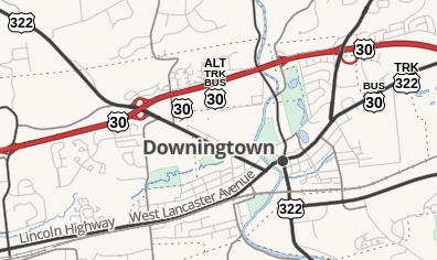
}The clip below shows the result where the Merritt Parkway (concurrent with CT-15) ends and the Wilbur Cross Parkway (name but no shield) begins:
Text layout functions
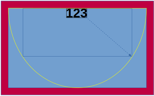
Text is laid out on shields in accordance with the specified textLayout value. The text will be drawn, measured, and expanded until it hits the edge of a text layout constraint. For example, an ellipse constraint would fill a padded shield like this, with the text drawn from the center and expanding until it reaches the ellipse:

Not all constraints are center-specified. For example, the southHalfEllipse constraint would grow from the top of the shield as follows:
The supported text constraints are:
diamondellipserectroundedRectsouthHalfEllipsetriangleDown
Defining drawn shield shapes
If shapeBlank is specified, the shield will be drawn as a shape. This needs to be specified with a drawing function, drawFunc and a params block the describes how the shape will be drawn. The draw functions are as follows:
drawFunc |
|
|---|---|
 |
diamond |
 |
ellipse |
 |
escutcheon |
 |
fishhead |
 |
hexagonVertical |
 |
hexagonHorizontal |
 |
octagonVertical |
 
|
pentagon |
 
|
roundedRectangle |
 
|
trapezoid |
 |
triangle |
The following params options can be specified:
-
sideAngle- indicates angle (in degrees) at which side edges deviate from vertical. Applies totrapezoid,pentagon,hexagonHorizontal,octagonVertical. -
fill- specifies the internal fill color. -
yOffset- indicates height (in pixels) at which the bottom and/or top edges deviate from horizontal. Applies toescutcheon,pentagon,hexagonVertical,octagonVertical. -
outline- specifies the outline color. -
outlineWidth- specifies the width of the outline. -
pointUp- applies to several shape types and specifies whether the pointy side is up. -
radius- specifies the rounding radius, in pixels, to use for corners. -
radius1- Corner radius of pointed side of pentagon (defaults to 2) -
radius2- Corner radius of flat side of pentagon (defaults to 0) -
shortSideUp- fortrapezoidonly, a boolean which specifies whether the short side is up or down.
Custom shield graphics
In addition to the stock drawing functions, a custom draw function can be specified. paDot and branson are included as examples of this, for rendering the Allegheny County belt system and the Branson, Missouri colored route system. See the file src/custom_shields.mjs for an example of how this is done.
Documentation
See TypeDoc generated documentation for detailed API information.